-
Search

| A LETTER FROM THE EDITOR |
|---|
|
March 4, 1979
| ||
|
Dear Fellow Paddlers
| ||
|
I'm not sure I'm ready yet. The temperatures have been pretty low just recently... and I haven't gotten much skiing in yet. And the rivers, they're still frozen pretty tight! I mean, I have been checking them a little more lately.
You all know I do enjoy the whitewater season ... that feeling you get when you untie your canoe from the garage rafters (or dig it out of the snowdrift beside the house) ... beginning to "see" the rapids you'll be running as you lash the extra flotation into your canoe. There's the anticipation as I carry my boat down to the water the first time, with my wet suit boots mushing down into the corn snow. And I always really enjoy that first minute on the water, when all the old moves you think you (and your partner) have forgotten come back, and the first eddy turn of the year is only slightly tentative. Those are great moments. Come to think of it, I am ready! WELCOME BACK!
| ||
|
Larry Thomson
| ||
| UNITED STATES OF AMERICA BEFORE THE FEDERAL ENERGY REGULATORY COMMISSION |
|---|
and
The City of Burlington, Vermont,
Electric Department
Project No. 2756
(5th) QUARTERLY REPORT
November 1, 1978 - January 31, 1979
CHACE MILL HYDROELECTRIC PROJECT
WINOOSKI RIVER
CITIES of WINOOSKI and BURLINGTON, VERMONT
|
A. PROGRESS DURING QUARTERLY REPORT PERIOD
1. Project Plan Refined
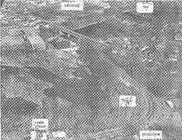
Further work on optimizing the project plan selected in the previous quarter has brought about some changes. Most notable are the relocation of the powerhouse to the downstream end of the tunnel, and a redesign for two major turbines instead of three. An aerial view of the site with major pro- project features depicted is shown on Page 1.
The latest specifications are:
2. Gauging Stations
Instrument housings and piers for the two gauging stations have been completed to designs furnished by the U.S. Geological Survey Boston office. Gauging instrumentation has been scheduled for installation.
3. Agency Liaison
Meetings and other contacts to explain the evolution of the project and seek input from concerned agencies took place with:
- City of Winooski
- Landscape Architects Kiley-Tyndall-Walker
- U.S. Fish & Wildlife Service
- Chittenden County Regional Planning Commission
- Winooski Valley Park District
- Burlington Park Department
- Green Mountain Power Corp.
- Vermont Division of Historic Preservation
- Vermont State Archeologist ( and a. contract archeologist
- Vermont Public Service Board
4. Financial
General Bond Resolution work is 70% complete, IRS regulation review 95% complete, and long term rate effects 50% complete. Alternate source analysis is 90% complete, with the exception of hourly own load dispatch calculations in specific time frames.
5. Expenses
Expenditures by Burlington Electric on the project through January 31, 1979 exclusive of interest income and expense accruals totaled $355,197.
B. WORK CONTEMLATED FOR ENSUING PERIOD
1. install stage/flow and temperature instrumentation in the two gauging stations.
2. Continue project optimization, with emphasis on machinery evaluation.
3. Obtain & integrate U.S. Fish and Wildlife fish trap conceptual design.
4. Continue the general fish and wildlife study.
5. Arrange for springtime archeological survey.
6. Continue agency liaison, particularly with the City of Winooski.
7. Continue F.E.R.C. license application work.
8. Continue financial investigations and updating of cost analyses.
John E. Berryman Liaison Officer, Project 2756 c/o Burlington Electric Department 585 Pine St. Burlington, Vermont 05401
February 15, 1979
JEB:fts
| TRIP REPORTS |
|---|
St. John's River Trip (From Log Book of Bob Dodds): May 26, 1978
| Participants: | Bob Dodds, Dennis Dodds, Al Roberts, John Mosley, Frank Walsh (from Poughkeepsie), Peter Hornbeck and Tim Ramsey (from North Creek, NY) |
May 26th
Big day arrives. Frank, Pete, Tim and Dennis stay at my house and we rise and shine at 4:00 a.m. Even Pete! He can't believe it. He thought the only 4:00 o'clock was p.m. My dog Nikki is upset, she knows she's not going.
We meet Al and John in Jeffersonville at 5:30. We watch a beaver swim up the Lamoille River. Somehow it seems like a good omen. We stop in Newport for a lumberjack breakfast and then drive into Canada. This is very pretty country with a lot of nice small farms. It looks like Fairfield in many ways. Highlight of this part of the trip was the girl on the tractor! Right guys?!!
We arrive at St. Auralie at 11:30 am. Our road permits are in order and we have no problem passing through the border. The drive to Baker Lake, our put-in, only takes about 25 minutes. We load up the gear and get ready to depart. Dennis and I are in the "Tripper", Frank and Tim are in the "Explorer", Al and John have a "Voyager" and Pete is in the "Mother Ship, a 15' touring kayak.
We start our paddle down the St. John. After all the talking and planning, this is a very special moment.
We only do a real easy 6 miles this day. Everyone tries a little fishing. John gets the first fish, a small brookie. We all get some fish, but most of them are a junk white fish.
Our first camp is nice, it's at the junction of the river and a small stream coming out of a beaver pond. Supper is Al's specialty- Shish-ka-bobs, done over the open fire. For those who have tasted it, I don't have to say anymore; for those of you who haven't, I hope you get a chance some day.
Everyone goes fishing after supper. I catch a sucker and John gets two nice brookies. Must be his worms. Dennis falls in the beaver pond and decides to go swimming.
Back at camp, its time for the new equipment shootout. Al whips out his new super air mattress to the cries of "candy" and "puss". John breaks out his new "L.L. Bean" raingear and everyone proclaims a dry week for sure. Tim has a new 5 pc. pack fly rod and his old spoon and not much else. A true professional. Frank breaks out his new 60/40 parka to ward off the evening chill. Pete and I start comparing our new Swiss army knives to see who has the most options.
Just when we decide I've got the edge with a wood saw, Dennis whips out the BMW of Swiss army knives, a super 30 option special and knocks us both out of the competition.
Everyone agrees that canoe trips are good for the economy. After a cup of Yukon Jack, we hit the feathers. Frank sleeps under the stars.
Saturday
Good start this morning. Breakfast is French toast and trout. Eat your heart out Mindy. We start out with Tim in the touring kayak and Pete paddling with Frank. Pete is definitely a kayak man. Weather is beautiful again. I get on the board with two trout and we catch five altogether. We k-eep catching these whitefish (bonefish). Dennis decides to keep two to try and eat.
As we paddle down the river, we spot a logging bridge and Frank says"Wouldn't it be nice if we could stop and buy a beer". When we get to thebridge, we see three fishermen standing there, it turns out to be some guys that Frank and I know from Poughkeepsie, NY We not only get our cold beer but some fresh worms too! (Watch out now John!)
We stop at a beautiful campsite. Everyone goes for a swim at night. Water temp is 62 degrees and the air temp is still in the 80's. Chicken and stuffing for supper. We sit around after supper and try to come up with a nickname for Al. Pete says "How about St. John's Al?" It's a good name because he is definitely the leader of this trip.
Sunday
A long day ahead - about 20 or 25 miles. I paddle the kayak and after a few minutes, we get along just fine. Dennis and Pete are in the Tripper. They have a few problems getting the kinks worked out and almost dump it. Pete starts playing "candid camera" with my Canon and shoots up half a roll of film. Boat builders think they are so damn creative!
A large group of people with slalom kayaks paddle by. They are headed for Big Rapids to play. We share our campsite this night with a large group. One of the couples is Bob and Marilyn Courtney who have done a lot of racing in the Northeast. We have an interesting conversation. We didn't fish at all today although the group we shared camp with had some real beauties they caught on wet flies. It clouds up at supper but no rain. The river is dropping fast - about 2-3 inches a day.
Monday
Got up with the bugs today. Man, they are fierce. The only long sleeve shirt I have is a blue chamois and they love it. Cooked breakfast with a bug net over my head. Almost not worth eating!
We stop about two miles downstream to fish and really get into the trout. Frank gets two beauties and Tim scores with the new fly rod and flies. Dennis is paddling the kayak today. It's his first time ever and after a little warm up, he does really well.
We have stopped to fish again when "The" ironboats come by. Now seeingironboats (aluminum canoes) coming down a river is a very common sight so theseshouldn't have been any different except for one thing, the bow paddler in the lead boat was a very healthy young lady paddling "Topless". You should haveseen seven guys dive for their cameras. Al happened to have his 200mm telephoto-lens on and he blazes away. But then being ever the avid canoeist, he decides to get a closer look at that Grumman and he and John take off in hot pursuit. Shades of Gene Jensen and Ralph Sawyer.
It's another super hot day and the tans and sunburns are shaping up. We were going to camp at 7 Islands but we don't like the looks of it so we head for Priestly Bridge. They are in the process of rebuilding it so we bag it for Priestly Rapids. Just before we pull into camp. Al finds a six-pack of Schlitz/ 16 oz. eddied out behind a rock. Hot stuff! This almost makes up for the sixer he left behind in the trunk of the car. We pull into camp and it turns out to be a good move to have kept paddling because we get a nice site all to ourselves. Supper is spags with salad and garlic bread. Super!
Tuesday
Pancakes and Buckhollow Gold (syrup) for breakfast. Dynamite. We need all the help we can get because today is Big Black Rapids. We stop and fish a lot and get about 14 or 15 more brookies. Dennis breaks the ice with a nice 10" one. We finally get to Big Black and after scouting it out, everyone makes a clean run. It's kind of a let down after all the reading we had done. It's only Class II at best.
We get down to where the Big Black River joins the St. John's and decide on the community campsite because it has access to the spring. Bugs are starting to be a semi-pain. Everyone agrees that the mosquitoes are tolerable but the black flies have to go! Beef stew and trout for supper. This trout could get to be a habit. Temp is still 77 degrees at supper. Frank's back is acting up so he will pass on paddling the kayak.
Wednesday
This is our layover day. We canoe up the Black River and spend a real easy day swimming and fishing. Frank has a big day fishing as he bags eleven trout. Pete is in the kayak and he paddles up on a bull moose who wants to use the same part of the river as he does. He wisely concedes the right of way to the moose. Pete also paddles up behind a very pregnant doe deer.
We get back to camp just before supper and just in time to beat a heatthunderstorm. First time on the trip so we can't complain. After supper, we talk to two professional guides from the Eastern part of Maine. They are nice guys and they give us some good information. We have a little cup of Yukon and hit the feathers. Surprise in the tent, No-see-ums. Man, they are incredible. Dennis and I resort to an old woodchuck trick that we had heard about, Vicks Vapor-rub. Hard to believe, but it works great!!
Thursday
It rained hard all night but it has stopped by the time we get up although it is pretty cold. We grab a quick breakfast and hit the river. The rain brought the river up about six inches. All the feeder streams are really rushing. John gets a 12" brookie, the biggest of the trip so far. At the next brook down, I top it with a 13" one. Dennis and I do real well at the Little Creek. Al is pushing hard all day and we have 18 miles done bylunchtime. Another 10 or 12 miles will put us in camp. We take it easy in the afternoon and spend more time fishing. Between the seven of us, we catch 30 by supper time. We save some for breakfast to go with the pancakes.
We had tuna casserole for supper and depending on who you asked, it waseither terrible, horrible, retched or all of the above. It was definitely the worst meal of the trip. Must have been the tuna, right Al? Good thing we brought Tim along. He cleaned this stuff up like it was the best meal he had ever eaten. The way he eats he should weigh 250 instead of 150!
Friday
Heading for the finish - this is it. We eat breakfast of pancakes, trout and the last of the Buck Hollow Gold to get ready for Big Rapids. This is the best whitewater of the trip. It's definitely Class III. This is a good time of the trip to hit the heavy water. The boats are all pretty light and riding high (we've eaten everything but the buckets!) and it's the last day of the trip so taking a chance on a swim is not as big a risk as it would have been earlier in the week.
"St. John's Al" explains that there is a dry route down the left side but everyone heads for the middle. Pete goes first with the mother ship. He has the Bell Topex on so we know it's big water. He makes it O.K. which I'm glad of; he has my camera. All other boats make it through with no problem (other than a little water in the Explorer, eh Frank?)
Dennis gets his whitewater baptismal and does really well. Class III water with a boat load of gear is not an easy task for a rookie but he handles it with ease. The crash training course from NVCC pays off.
We arrive at Pelletier's at 3:00 and head for a cold beer. We pool our left over trip money and get seven T-bone steaks with all the fixin's. We get a chance to talk to the natives at Dickey and St. Francis and find that about 90% of them are against the dam. They are very much like people in rural Vermont, they have their own lifestyle and they don't want it messed up with the boom town atmosphere that the dam building would create.
We sit around our last campfire and recall the events of the past week. Everyone of us has some wonderful memories to take home.
As for myself, I have to say it was one of the most enjoyable trips I had ever been on. Good food, fantastic weather but most of all six real nice guys to be on a canoe trip with!
The Back Ponds of the St. Regis Canoe Area (by Richard Allen): August, 1978
| Participants: | Fuller Allen, Richard Allen |
The St. Regis topo map is one I have worn out through constant use. I had talked about the back ponds for several years, but I hadn't gotten around to making the trip. I had canoed the more accessible ponds on several occasions: Long, Turtle, Slang, Little Clear, and St. Regis. A hot week in August proved to be the best time to take this trip.
The biggest challenge would be taking the long portage in only one trip. It would be a good test of our ability to pack light. My father's 15-foot, 40 lb. cedar strip Stalek would be ideal in this situation.
The weather was hot and muggy and the forecast was for more of the same. Our first cut in gear was our sleeping bags. I took a wool blanket and a sheet. My father had a light sleeping bag cover. Our pads were the combination air and foam type - very comfortable. We took freeze-dried food, but no stove. We also rejected life jackets and a spare paddle.
Our two-man tent weighed 7 lbs. Clothing was light. But my father did bring three hats. He wore them all -- at the same time -- to cushion his head during a two-man carry.
We launched on Little Clear Pond. We paddled north to a six-tenths of a mile carry into St. Regis Pond. This would be a good test of our ability to make one trip carries. We had consolidated all the gear into a Hine-Snowbridge internal frame pack and a day pack. I took the day pack and the canoe. Fuller took the big pack and the paddles. The mosquitoes were biting on this carry so we moved quickly to St. Regis Pond. The trail is well-maintained so we had no problems.
We headed for a big island on St. Regis Pond to lunch, swim, and rest. Then we headed west to a fish control dam at the end of the pond. Here we would pick up a spur road that would lead us to the truck trail (closed to vehicles) that ends at Fish Pond, the biggest of the back ponds.
The condition of the trail is in the canoeist's favor. It is smooth and wide. There is some elevation to contend with. We rested several times along the way. It took about an hour to cover the two miles. We did do it in one trip. Fish Pond is beautiful. It sits at the base of St. Regis Mountain. The north shore is dominated by rock cliffs and abrupt ledges.
The weather was threatening so we set out for one of the two lean-tos. We found the one on the south shore empty, so we quickly set up camp. There were two other parties camped on Fish Pond: two backpackers and four canoe- ists. The rest of the afternoon was spent gathering firewood, swimming, resting and exploring the pond. Our supper was cooked over a fire between rain showers.
We went to bed early. About midnight a powerful storm hit with rain and high winds. We were snug and dry in our tent.
The next morning we packed up and proceeded west out of Fish to do some serious pond hopping. We went into Little Fish, Little Long, Lydia, back to Little Long, to Kit Fox, to Nellie, and finally to Bessie Pond. We tried to avoid the carry between Nellie and Bessie by canoe-dragging on the creek" that connects them. That was a mistake. There wasn't enough water to float a leaf and we stumbled along without sneakers in an attempt to save our dry foot gear for camp.
Most of the names of the ponds in the St. Regis area are clear in their origin, but Nellie and Bessie often get me conjuring up wild imaginings. Back in the late 1800's there was a lumberjack with two hard-working mules ... Or maybe Paul Smith immortalized two lost loves. Who knows?
We set up camp on a bluff overlooking Bessie Pond. This spot had been previously scouted the year before during a hike into Bessie from Long Pond.
We canoed on Bessie gathering branches from dead trees along the shore. I was half out of the canoe when the branch under me broke; this upset the delicate balance. Fuller was soon sitting on the bottom of the pond. We headed back to camp to dry out. By now the weather was cooler and we were wearing most of the clothes we had brought.
After supper we decided to carry the canoe down the trail to Long Pond. We made this decision because we knew the trail was in very rough shape and we felt that it would be easier to tackle it with two trips separated by a night's sleep. So we stashed our canoe in the bushes at the end of the trail after one and one-half hours of walking. It was rough going -- muddy and rocky. Long Pond was busy and noisy with many people canoeing in the gathering dusk. We were happy to hoof back to the solitude of Bessie Pond.
Our walk out the next morning was pleasant with-only two packs. For some reason Long Pond was deserted. We enjoyed fine weather for the carries into Turtle, Slang, and Hoel Ponds. We took out on the south shore of Hoel Pond. The car was a quick hitchhike away. We had taken 11 carries and canoed on 13 ponds from Wednesday morning to Friday afternoon. I had explored the back ponds of the St. Regis Canoe Area and it had been worth the effort.
Footnotes and post scripts: Avoid the carry between Bessie and Long Pond with your canoe. Keep it as a nice day hike from Long Pond. The truck trail between St. Regis and Fish Pond is the best route in and out of the back ponds.
Bring another pair of wool socks and some long underwear. We had foolishly believed the weather forecast.
Sources:
- Topographical map: St. Regis quadrangle.
- Adirondack Canoe Waters: North Flow by Paul F.Jamieson
CANOEING THE ANDROSCOGGIN by Richard Allen: September 30, 1978
| Leader: | Al Roberts |
| Participants: | Bob Durkin, Al Roberts, DIck Allen, Mo Desilets/Connie Desilets, Fred Jordan,and Bill Hampes |
?We were off before sunrise but the forecast was very promising. We were confident we would have beautiful weather. It proved to be so: sunny skies, a balmy wind from the south and 65 degrees.
The drive from the Burlington area is about three hours.
If you stop at Dunkin Donuts in St. Johnsbury) (such as we did),
add 15 minutes to your driving time. The foliage was peeking out along the Winooski Valley, and peaking in theAmmonoosuc and Androscoggin Valleys.
The Androscoggin is attractive to boaters because it is dam controlled and backed up by the Rangely Lakes. This allows for Class II and III rapids well after the other rivers become very low. At typical August and September water levels it cannot be called technical boating. Most of the challenge is in keeping your boat aligned with the current and avoiding the large waves that can swamp an open boat. There are not a lot of rocks to dodge, and one has to search hard for the eddies. But the swift current makes it a demanding river.
There are three distinct sections that provide most of the rapids. The first section we tackled starts at the Mollidgewock Campground, 3miles south of Errol. The two to three miles of river below the Campground has a stiff current and short stretches of mild rapids.
There is one spot where, the river hugs the road, and this usually guarantees spectators for those wishing to show off. From left to right the drop gets progressively more challenging. At the bottom of the drop on the right side is a huge pillow formed by a washed over boulder. Along the right hand shore is an eddy that is gaining fame as the Al Roberts Action Photo Eddy. What you are suppose to do here is come blasting down the right side, fly over the boulder, execute a perfect eddy turn and smile. This is so your exploits can by recorded for future NVCC meetings. (Make arrangements with Al ahead of time for this service.)
Our morning run was over by noon, so we headed north to Errol to lunch at the bridge. Our lunch spot gave us a direct view of the big stuff below the bridge. Our meal was a quick and nervous affair. We were feeling the tension of the upcoming run that starts below the dam north of Errol. and ends half a miles later just below the bridge. Here we would be contending with the big- gest waves. It is a short run, so we planned on doing it twice.
The Desilets provided us with our first close call. In the short stretch of rapids below the dam they hit a rock, got turned sideways and took in enough water to flood the rink at Leddy Park. For some reason they didn't go over. Mo has designed a unique flotation device that may have saved them. It consists of an inner tube covered by a piece of Georgia Pacific dark stained paneling. We are not sure of the function of the paneling, but the Desilets had the classiest canoe on the river.
We did do this stretch twice and enjoyed the fast ride through the big waves. Now we were headed for the third section: Pontook Rapids. We put in below Pontook Dam and did the first set of rapids. We rested in a flat section before proceeding to the final series of mostly Class II water. This last part proved to be the most enjoy-.Able and It was an excellent way to end the day. One canoe swamped near the take out. It was rescued without difficulty.
We all appreciated the dry clothes waiting for us in the cars. We were finished canoeing by 5:00. It had been a full day. We stopped at a Texaco station for a supper of beer and munchies. On the way back, to Vermont we relived the day's adventure, and talked of the white water we could look for next spring.
| NVCC Limerick Contest |
|---|
The first annual Northern Vermont Canoe Cruisers Limerick Contest officially opens today. The rules are:
- The theme of your Limerick should be related to paddling (however distantly).
- It should be submitted on or before May lot, 1979.
- It should be printable in the Bow and Stern without melting our press.
To get you in the mood, here's a sample:
The "Cruisers" on rivers, do travel
Though their boats, they often unravel.
They run chock-a-block,
Right up on a rock.
And with their boats, turn
that rock into gravel.
| TRIP REPORT FORM |
|---|
TRIP:

DATE:

LEADER:

Number of Boats:	Kayaks:__________	Canoes:__________

Participants:	_______________________ ______________________________

	_______________________________	______________________________

	_______________________________	______________________________

	_______________________________	______________________________

	_______________________________	______________________________

	_______________________________	______________________________

	_______________________________	______________________________

	_______________________________	______________________________

	_______________________________	______________________________

	_______________________________	______________________________

Report:________________________________________________________________

_______________________________________________________________________

_______________________________________________________________________

_______________________________________________________________________

_______________________________________________________________________

_______________________________________________________________________

_______________________________________________________________________

_______________________________________________________________________

Mail to:	Larry Thompson
		62 White Birch Lane
		Williston, VT 05495
Trip Leader,
Have you:
- scouted or paddled this river before?
- checked for recent changes or obstacles?
- informed the participants of details of this river?
- filed a "float plan" with someone, if the trip is into wilderness areas?
- checked out the participants to see their skills are adequate for this trip, under these conditions?
- seen to it that personnel rescue gear is on hand (throw lines, sleeping bag to treat hypothermia, etc.) as well as boat rescue equipment?
- divided the boats into manageable groups of no more than seven with a leader and sweep for each?
- assigned experienced boaters to travel near less experienced ones?
- reviewed procedures to follow for safety on the river?
- reviewed the procedures to follow in case someone capsizes?
- checked boats for: extra paddles, adequate life jackets, bailers, painters, flotation, and no clutter to trap people during a turnover?
- planned to include in your report a detailed account of any accidents, their causes, the procedures used, and their effectiveness?