-
Search

| A LETTER FROM THE EDITOR |
|---|
|
Dear Fellow Canoe Cruisers,
| ||
|
Welcome back! It's just about time for the canoe cruisers to trade in hockey sticks and ski poles for paddles and knee pads. This year, the club will be making some changes that should add to everyone's enjoyment. Things like holding two pool sessions (one for closed, one for open boats), and scheduling some training runs on the rivers a bit later in the season when new members (who may not own wetsuits) will be better able to attend.
The whitewater schedule will include a few new rivers this year. (Variety being the spice, and all.) Some thought has already been given to the Flatwater Season. Some ideas include the scheduling of only two or three very special flatwater trips. Overnighters that folks can really enjoy. In addition, I hope to have a "guide" to the club members' favorite flatwater haunts, for the June edition of Bow and Stern. We'll tell you where some great canoeing is, and let you enjoy these places on your own. So enjoy the spaghetti, enjoy the Bow and Stern, enjoy the meeting and get ready to enjoy a great new season on the water.
| ||
|
Larry Thomson
| ||
| MINUTES OF THE EXECUTIVE BOARD MEETING JAN. 19, 1978 |
|---|
The following positions for 1978 were forwarded for nomination. Voting on these, and nominations from the floor, will take place tonight at the February meeting.
		President		Norm LciVoie
		Secretary/Treasurer	Dick Trudell
		Bow & Stern		Larry Thomson
		Whitewater Chairperson	Tom Conlon
		Wbitewater Training
		Committee Chairperson	Louise Amidon
		Flatwater Committee	Al Roberts
					Bob Dodds
					Dick Allen
		Chiott Race		Ed & Louise Amidon
		NVCC Picnic Regatta	Bob & Melinda Dodds
It was announced that Lois Dodge would arrange the February meeting, and that it would be a spaghetti dinner. Mary Ann Ponder will make arrangements for the June meeting.
A discussion of the upcoming Whitewater Season was held, and some new rivers were added as possibilities. One scheduled trip per weekend was planned, leaving one day (Saturday) open for informal groups to form.
This led into a discussion of the whitewater training program. Tentative plans include one blackboard session and two pool sessions. Much discussion followed on the idea of moving the training program ( on the rivers) back further into the season, when the temperatures are warmer and training is easier.
A possible change of date for the Chiott Races from July 4th was discussed. It was generally agreed that such a change would be beneficial in boosting attendance and interest.
A discussion followed corcerning the BED proposal to dam the Winooski. A committee of Dick, Trudell and Fred Fielder will write letters to the appropriate people and indicate an interest on the part of the club. It might be possible to construct canoeing facilities in conjunction with the dam. (See letter from Dick Trudell farther on in this issue-Ed.)
Without making formal commitments, it was agreed that the NVCC would be interested in working on a portage trail and campground at the Bolton Falls area on the Winooski.
- Dick Trudell
| Flashes from the paddle ... |
|---|
Normand and Blair Lavoie will be taking orders for silk screen imprints of the club emblem which can be put on sweatshirts, T-shirts, jackets, or even your longjohns! Approximate size of the emblem is 5" x 7". The cost will. be $2.50 with your own shirt, or $4.00 if a shirt is not provided. They need to have a minimum order of 25. Call 863-5456.
Patches and Decals are still available for $1.25 each. Contact Norm Lavoie (863-5456) or Dick Trudell (655-3554).
| TENTATIVE WHITEWATER TRAINING PROGRAM |
|---|
	March 22........... Blackboard Session-Legal Aid Office,Burlington
	March 28........... Closed Boat pool. session, UVM Pool
	March 29........... Open Boat -pool session, UVM Pool
The first scheduled trips during the whitewater season will be training trips. We will also have additional training trips in the May-June time frame when the water warms up some.
| VERMONT CANOE GUIDE |
|---|
Efforts are underway to produce a canoe guide to Vermont rivers and streams. This effort is being spearheaded by Bob Manning of UVM with the assistance of other members of the Canoe Cruisers, particularly Norm Lavoie and Dick Trudell.
The purpose of this effort is to produce a readily available, low cost guide book that is devoted exclusively to floating Vermont streams. The guide is slated to be published by the University of Vermont Extension Service.
A three step process is being used to prepare this guide. First, UVM students prepare a base map for each river to be included in the guide and make notations on this map regarding access points, water conditions, portages, etc. This original information is drawn from existing guide books. The second step involves meeting with appropriate members of the Canoe Cruisers who are familiar with the rivers. During this meeting information is updated, corrected, and supplemented. The final step is the preparation of a written narrative for each river, based on the information collected.
The guide is projected for completion sometime this summer.
| From the Flatwater Committee |
|---|
The club plans to hold THREE, OVERNIGHT trips during the months of JULY and AUGUST. These will be announced at or around the June meeting.
The NVCC Picnic Regatta is planned for July 30th, this year. Watch for further announcements!
| River Recreation Study |
|---|
A study of the recreational use of Vermont river's and streams is being conducted by Bob Manning, Professor of Recreation Management at the University of Vermont. Bob is a graduate of last Spring's whitewater classes and a member of the Canoe Cruisers.
The study is designed to collect information on the type, amount, and distribution of recreation use on Vermont rivers, This information will be used to assist in the management of rivers in such ways as proper provision of facilities, including access points and camping areas, and avoidance of problems such as user congestion and conflicts.
Information will be gathered from river users by means, of a personal interview questionnaire, Interviews will be conducted on representative river types throughout the state, The study will collect information over the spring and summer of 1978.
The study is being guided by an Advisory, Board made up of public agency representatives,, major river recreation user groups, commercial enterprises having an interest in river recreation and public utilities and other agencies having large riparian land holdings, Norm Lavoie is a member of the Advisory Board representing the Canoe Cruisers.
The study Is being sponsored by the Vermont Water Resources Research Center.
- Bob Manning
| TRIP REPORTS |
|---|
Nantahala, Ocoee, Chattooga Section 4: June 10-19, 1977
| Leader: | Dick Trudell |
| Participants: | Dick Trudell, Roger Belson, Rich Brainerd, Kim Brainerd |
This trip started out with about 20 potential boaters and materialized into four stout- hearted diehards, two of whom were recruited at the June NVCC supper three days prior to departure. After many long driving hours, three weary travelers reached Connecticut at Roger Belson's apartment and spent the night on a hardwood floor. Awakening the next morning to the fresh crisp smell of poached eggs and ice cream, coffee and toast, the four started off cramming bodies, gear and boats into Roger's spacious Saab and drove on to historic Wytheville, Virginia (renowned as the birthplace of Mrs. Woodrow Wilson). To the tune of dueling banjos the four winded their way through the Smokey Mountains and the Hare Krishnas and arrived at Wesser, N.C. only to be dismayed at the trickle of the river. "Oh, no," quoth Roger. "Fear not," counseled Dick, "The River will rise again (it's dam controlled)."
So taking up their boats the four put in at the put-in and took a leisurely Sunday afternoon boat ride, dodging cloud banks, stray rafts, and the 40 0 water. The decision was made that tomorrow we'd wear our wetsuits in spite of the 860 sunshine. Arriving safely at the restaurant at the end of the run, they retreated to southern hospitality and good grits. The next day a large shadow loomed in our doorway, closely followed by Angus Morrison, the national C-1 wild water champion, who became our fearless leader for the next five days, He led us on a preliminary run down the Nanny and allowed an how we'd have more fun on closed boat water, the Ocoee, boiling, turbulent, muddy water (1300 CFS) raging down an eastern Tennessee valley, highlighted by the successful passage of Table saw and Double Corkscrew, the boater polished off THE HOLE at the bottom for dessert.
Not having enough the first day, the group came back for a second round the next day. After a hard days paddle on the Ocoee the four drove back to the Nantahala, put in at the takeout and paddled upstream, finally coming to an understanding with the river at Nantahala - Falls (Lesser Wesser) where they finished off the day playing in the Falls.
After a dinner feast, whitewater movies, vicious pillow fight and a hard nights sleep the four took the next day off and rafted down Section 4 of the Chattooga (scene of the movie "Deliverance"). After scouting it out, the four (nuts) decided that the Chattooga would be interesting in kayaks. Besides, what did they have to lose, it would be their last day whatever happened. At the put-in, the water ran 1.7 ft. (low-medium level) at the gauge.
They ran: Surfing Rapids, Screaming Rock Jumble, Left Turn, Seven Foot Falls, Stakoa Rapids, Raven Shoot, Entrance, Corkscrew, Track-in-the Rock and Shoulderbone, They omitted, through discretion, Woodall Shoal, Jawbone, and Soc-em-dog. Boat-eating hydraulics and undercut boulders with passages large enough to lodge a boater finalized their decision.
Bone-tired (no pun intended) the four shouldered their way two miles across flatwater to the takeout where Lake Tugaloo spat them on shore. As the sun set slowly on the southern sky the four bid adieu to the Carolina white waters and hastened to Roger's car for a quick 24-hour ride back North.
Paddle 50, Pack 12: A Week in Algonquin
| Leader: | Richard Allen |
The first shock came during the trip preparation. We were going to pack a week's worth of food, portage it several miles, and try to maintain an inviting variety of meals. We came up with a strange mixture of freeze-dried and supermarket food. The repackaging was a chore that took up several evenings. The simple plastic bag became our best friend. This was all a lot of work but it was well worth the effort.
We left early on a Saturday morning, took the scenic route through Alburg, and headed across northern New York for our border crossing at Cornwall. We were ready for this border check to be a horrendous experience. We envisioned a cold eyed customs officer demanding the complete disassembling of one Rabbit stuffed with four people, a lot of camp- ing gear, and two canoes. It didn't happen. We were quickly waved through and the long haul to Algonquin continued.
Ontario seems to consist of a lot of rolling farm land with some remains of the great forests that once lorded over the land. As we approached the Park the woods became thicker and every once in a while we would catch a glimpse of a lake being whipped up by the ever present wind, or "la vieille" as the voyageurs referred to it.
After a quiet night in the Tea Lake Campground, we consulted with the rangers at the Canoe Lake Access, obtained our interior permits and headed into the winds of Canoe Lake. (The first day's itinerary was ambitious. We wanted to get away from the settled part of the park as quickly as possible.
Our first portage was rather unorthodox. Each of us grabbed an easy hand-hold and walked each canoe (fully loaded) about 20 yards around a dam. But we knew at the time that there would not be too many places we could employ this novel method.
We soon passed into Joe Lake and picked out a point for a lunch spot. Just as we were pulling in, we spotted a "black dog" rummaging through a campsite across the channel from us. It brought to mind the many warnings we had heard about hanging up our food out of the reach of the bears. This ritual of tying up the food basket soon became one of the more entertaining and challenging activities after each night's supper. And on one occasion we seriously considered sleeping in the pack basket to leave the assorted powders in envelopes to the wild beasties down below. I'm sure their reaction to the freeze-dried raw beef would have been the same as ours: one taste and they would have sworn off camp robbing for good.
After lunch we continued in a northerly direction. and soon entered Tom Thompson Lake. This lake is not named for some fellow from Wisconsin and who worked in a beer yard there. Tom was a famous Algonquin artist. Anyway, we spied a cow and calf moose feeding on a distant shore. This, along with the loons that had kept us company, made us believe that we were in for a real "Park Safari African" canoe trip. We were wrong. The first day turned out to be the best for wildlife viewing. It was all red squirrels from Sunday on.
The first day was also to be the day of our longest portage: 2100 yards into Ink Lake. It would be a good test of our bodies, our packing, and our equipment. Everything was going fine until I heard a thump, and felt the canoe shift very quickly in the wrong direction. One of the nuts on a bolt holding the yoke decided to depart. A tool kit with extra nuts, bolts, wire and pliers was one of the things I had carefully ignored in my packing. I did manage to tie it together with some nylon cord. This was later reinforced with much duct tape. The whole wad lasted for the remainder of the trip. I had learned a lesson.
After three of us had made a second trip over the portage, it was late and time to camp. We set up camp at the end of the portage. Our big scare came in the morning when the local red squirrels decided it would he cute to drop 58 green pine cones out of the tops of the trees. This madness started at a very early hour and made a noise much like a giant snowshoe hare leaping twenty feet high to feast on our dangling banquet basket.
The next morning we canoed across the dark waters of Ink Lake and entered the narrow winding creek that would gain us passage to McIntosh Lake. We enjoyed the bog with its scattered tamarack trees as we approached McIntosh. It was still early in the day. We had decided to spend some time in McIntosh and try our luck with the fishing. And we had plenty of that, all of it bad. Algonquin is supposedly the home of the lake trout. He must have been on vacation that week.
We spent a quiet afternoon reading, bathing, and napping.
Tuesday dawned gray and cloudy. We knew we were in for a bit of rain. We held off our departure until the weather seemed to ease up. As soon as we loaded the canoes and headed towards McIntosh Creek, the heavens descended and it rained all day.
We had some tough portages to tackle in this weather. They were in rough shape and we had to deal with slippery rocks, rickety bridges, mud, and lining up a creek with about two inches of water. All this time we were being shown up by young fellows who were jogging down the trail with heavy wood and canvas jobs with no yokes. After all this frivolity, we still had four miles of canoeing before we reached Trout Lake. Trout Lake will be remembered for its beautiful cliffs and the superb job we did of rigging the food for the night.
Wednesday's weather was an odd mixture of showers and fast moving clouds, with a little sun thrown in for flavor. As we moved along the cliffs headed for Big Trout, we caught a glimpse of a silent bird that came down out of the trees and flew ahead of us to another perch. It turned out to be a peregrine falcon, and his home was a cage placed high up on the cliff by the Ministry of Natural Resources in an attempt to save this swift hunter from extinction.
Our supper that night was blessed with a sight of rare beauty. An evening shower was soon chased away by the wind and the sun came out to produce a perfect rainbow complete within our view. There was a pot of gold at the end of this one. It was Big Trout Lake in her early evening splendor, and we were sitting in the middle of it.
Thursday was to be another day of heavy travel. We were to head south down Big Trout, hop-scotch through several portages and paddle up Otterslide Creek. The wind was up strong, but it was against our back., end we practically surfed down the lake. A slight canoe jam occurred at the start of the first portage, but we soon spread out due to the different speeds of the parties. This had become a familiar pattern by the end of the week. There were a lot of people on the waterways and the portages, but we never really felt pinched when it came to finding a campsite.
To while away the long hours of canoeing we often broke into spirited song. Some of the tunes were legitimate, and others were corruptions of familiar themes; such as "I Met My Pretty Brown-eyed Girl Down by the 0tterslide". The voyageurs of the past were famous for several things: strength, storytelling, pipe smoking, and their singing. I now have a better understanding for their need to sing. But I am sure that the ancient spruce trees had never heard such a poor excuse for singing as that came from our lips.
"La vieille" blew with unrelenting fury on Otterslide Lake. We were encased in all our warm clothes. Down vest weather.
By Friday we had given up on any normal summer weather. We made an easy 800 yard portage into Burnt Island Lake. Into the face of a strong west wind, we paddled the length of Burnt Island, portaged into Baby Joe and Little Joe Lakes. It had been a long day. It sheer whim that caused me to shout to a group going in the opposite direction: "Do you have any beer?" They did. They were soon taking shelter under our tarp and passing around bottles of brew. The rain had started again. But their visit picked up our spirits in more ways than one.
Our supper that night was cooked over the small stove we had been carrying for many miles. The storm blew all night. We had a wet stove and a cold breakfast the next morning.
The weather turned sunny on our last day. We were soon back on Canoe Lake. The north wind let us sail back to the Access. I enjoyed watching the neophytes getting ready for their trip into the interior. I was smiling. I was wiser. It had been a low of hard work, cold winds, blisters, funny meals, regal scenery, insane loons, and finally a chance to blend with natural world. I was tired. But it was a satisfying tiredness. I was ready to go back...
ANDROSCOGGIN RIVER
(recalled five months later): August 27-28, 1977
| Leader: | Alan Roberts |
| Participants: | Alan Roberts, Bob and Melinda Dodds, Dick and Lucille Allen with friend Janet, Bill Hampes, Julie Ponder and (scribe) Mary Ann Ponder. |
The two days (Aug 27-28) on the Androscoggin River in New Hampshire were perhaps the most remarkable whitewater trip of 1977 for my daughter and me. Although the trip was scheduled in late summer when most Vermont river water-levels were too low for good whitewater canoeing, the dam-controlled Androscoggin River offered excellent canoeing conditions--fast rapids, fairly high standing waves, few rock gardens or ledges, and humanly tolerable water temperatures. An outstanding stretch of rapids runs just below Errol Dam, passes under the Route 26 bridge, then spills into a longer and wider section of flatwater. For the novice whitewater canoeist, this stretch of whitewater provides the opportunity to test and practice paddling skills and to experience the challenge of running-the-rapids, yet minimizes many of the dangers associated with this sport.
Other memorable moments during our overnight canoeing- camping trip included a fantastic dinner of marinated shish kebabs, wild rice, summer squash, and toss salad which we prepared at our riverside camp site. Who says that camping need be primitive?
In the early morning haze, we sighted two moose cows just across the river from our camp. The moose obligingly continued their river grazing while we turned car headlights on them for better observation. For flatwater entertainment, we explored the narrow, winding canals that coil through the marsh lands opposite the camp on Route t6 and admired the flora and fauna. Following another whitewater run of longer duration but less difficulty, we disembarked for lunch at the Seven Islands bridge. After a few second's consideration, the brave ones (or the foolhardy ones depending on who is telling the story) donned their life vests, leaped from the bridge into the rapids below and bounced along with the current for several yards on their backs with feet thrust forward. The final stretch of whitewater canoeing ran from below the Pontook Reservoir to the Junction of Route 110A and Route 16. Those canoeists who remained in the running came through the rapids unscathed and eager for a rerun of the action.
Hudson Gorge: October 30, 1977
| Leader: | Dick Trudell |
| Participants: | Chris McGary, Roger Belson, Rich Brainerd, Kim Brainerdt Dick Trudell |
A call on the telephone ... the water's up in the Hudson - 4.0 on the gauge -- want to run it?" The questioning reply -- "Do you know it's almost November -- it's going to be cold! ... , but...
It turned out to be a sunny day -- not real warm, but not too bad, if you could stay in the sun. We put in high on the Indian River, with its gauge at 1.0 -- the lowest for a non-scratchy trip -- and started down, taking our time to stop and play as we knew this would be the last time on the river before snow came. At the bottom of the Indian River, where it joins the Hudson --, "Hey, haven't I seen you before?" Another group of kayaks came down to join us; and, as it turned out, there were a lot of people on the river that day. The feeling that we had been so macho coming out this late in the season began to subside.
We played all the way down Blue Ledge and the Staircase and all the way to Big Nasty before we ate lunch, and it was still early in the day. Pretty soon though, the warming rays of the sun left and we were in the shadows of the Gorge - you could feel the difference immediately -- it was cold. The rest of the trip was spent determinedly paddling to get to the takeout before it got too cold. We were all shivering by the time we got the gear loaded and were on our way home (leaving the keys locked inside the car at the put in didn't help either, but a little minor surgery performed by our new intern remedied that). Would we do it again? Yes, probably -- in about six months.
| Re: Proposed Winooski Hydroelectric Plant |
|---|
|
Richard P. Trudell 39 Franklin Street Winooski, Vermont 05404 January 26, 1978
| ||
|
Mr. John E. Berryman Chief Engineer Burlington Electric Department 585 Pine Street Burlington, Vermont 05401
Dear Mr. Berryman:
| ||
|
The Northern Vermont Canoe Cruisers are composed of 100 families in the area
which share an interest in canoeing. Our interest is in both the whitewater and
flatwater aspects of the sport. We are extremely interested in any proposal
which would affect the streams and rivers of Vermont; and consequently are
interested in the proposal for the Chace Mills site. We are not opposed to such
a development, given the realities of the energy situation; but would like to
offer the following suggestions which could be incorporated into the development
plans.
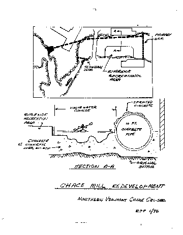
The river from just above the Lavallee and Roy building to below the falls is not canoeable, due to the natural formations and the dam itself. It might be possible to incorporate into your plans, a way to make this section of the river passable through the Installation of a whitewater course. This course could consist of a series of drops and pools, manmade hydraulics and boulders through which water flow could be controlled much as a scheduled dam release. This could provide recreation facilities for the growing number of whitewater paddlers in the area, as well as providing an aesthetic addition to the site. As another alternative to your site, I have prepared the attached plan. The primary dam would be located at the upper ledge and the 16 ft. diameter pipe located as in your first alternative to give you the best hydraulic capability. Since the flow of the river would be reduced by the quantity carried in the pipe, a method of retaining the aesthetics of a flowing river would be to narrow the channel. This would be done by the construction of a filled area extending out into the existing channel. It's shape and surface configuration would allow flood level water to sweep over the parent. Between the recreational area and the pipe, the remaining water would flow over a man made river bottom of such a configuration to provide a whitewater course for boaters. If the 16 foot pipe were concrete, it could be made to blend into the surroundings by applying a sprayed on colored concrete surface. A secondary dam located below the Winooski Bridge would provide a quiet water area at the end of the course, an area where stocked fish could be caught, and still allow enough water to continue down into the Salmon Hole to keep it viable. It is our belief that B.O.R. funds might be available for this development and by copy of this letter we are informing State agencies of our proposal. For your information, we have enclosed a reprint of an article that appeared in American Whitewater concerning a reclamation project in Denver, Colorado. It is the position of the Northern Vermont Canoe Cruisers that a joint effect of the utility companies, local municipalities, recreational authorities and interested citizenry can effectively develop a project that will be pleasing to all.
| ||
|
Richard P. Trudell Secretary, N.V.C.C.
| ||
|
cc: Ms. Mary Esther Stetson Green Mountain Power Corporation
Peter Clavelle
Edward Koenemann, Director
| ||
|
| DENVER'S WHITEWATER CHUTE |
|---|
|
| WHITEWATER CHUTE South Platte River, Denver, CO |
Construction will begin this fall on the nation's first manmade whitewater facility, to be located on the South Platte River in the heart of Denver, CO. The facility has been incorporated into the South Platte River Development Project, the aim of which is to clean up the ten miles of river flowing through the heart of Denver and turn it into a recreation area. One of the Denver architects consulted on the Project was Ron Mason, one of the nation's top-ranked kayak racers. He proposed turning part of the area into a whitewater park on the order of the Olympic course used in the Munich games in 1972. The idea was accepted and a site located.
Work then began on the 1:20 model of the proposed chute, using the hydraulic model testing facilities of the Bureau of Reclamation laboratory. The staff, consisting of Ron Mason, four Reclamation staff members and numerous kayaking enthusiasts, volunteered their time for the project so that costs were limited to materials used. The chute will provide a Class III run of 500 ft., having a drop of 5 ft. Velocities will reach 14 ft./sec. with maximum flow of 325 cfs. The width ranges from 25 to 40 feet and the depth from 30 to 64 inches. Provisions for removable slalom gates will be included in the construction.
Geared as a recreational facility for all levels of kayakers, rafters, canoeists and innertubers, this public course has no holes, ledges or drop-offs that might trap a person or boat. Guide lines for operating the chute will be established by the city working with the Colorado White Water Association. Sufficient water permitting, paddlers will be allowed to use the facility year- round. Scheduling the various types of activities during periods of heavy use is planned to avoid overcrowding. (Photos and information courtesy of the Bureau of Reclamation Engineering and Research Center, Denver, CO.)
VOL. XX/4 p.147
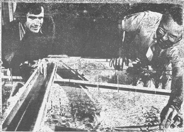
| Ron Mason (left), originator of the whitewater park proposal, and Bill Simmons, a Reclamation- hydraulic expert, send a hand-carved model kayak down the chute. Bureau of Reclamation - photo by R. A. Pauline |
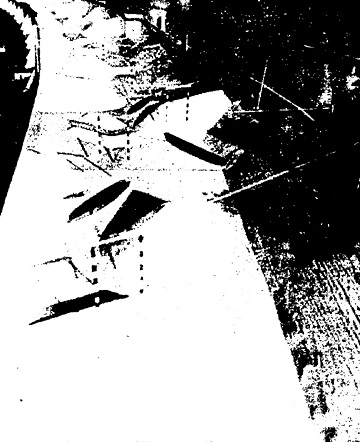
| Berms in kayak-canoe chute generate waves and eddies producing white water. The berms also allow the paddlers to work their way back upstream without leaving the water. Bureau of Reclamation photo by R. A. Pauline |
|
Bureau of Reclamation Engineering and Research Center Denver, Colorado 80202
| ||
|
Gentlemen:
| ||
|
Would you kindly forward any literature that you might have on the man made whitewater facility constructed in Denver. There is a hydroelectric project proposed
for the Winooski River between Burlington and Winooski, Vermont and it may be
possible to incorporate something similar to Denver's plan at the proposed site.
Enclosed is a letter that our club sent to various officials that will give you some background on the situation. We thank you for any assistance you can give us.
| ||
|
Sincerely,
Richard P. Trudell
| ||
|
RPT/slp Enclosure
| ||
| CLUB SAFETY RULES AND SUGGESTIONS |
|---|
Mandatory equipment for participating canoeists includes:
		1. Life jackets for each member of the party
		2. Spare paddles
		3. Adequate flotation
		4. Painters on the bow and stern of the canoe
LIFE PRESERVER: Anyone who has known the relief of popping effortlessly to the surface after having been flipped into a rapid (and this means every paddler of much experience) has quickly to appreciate his life preserver. Elementary safety demands its use when paddling in whitewater, for, with few exceptions, the lack of a life preserver has marked every fatality in white water. A vest preserver, either inflatable or with a buoyant filling, is recommended. It must have. plenty of flotation and should fit so that it will interfere with neither paddling nor swimming. It should be cut high under the arms or have a crotch strap to keep it in place. No outer clothing should be warn over it. Belt preservers of any kind are inadequate, since their buoyancy acts at the wearer's middle instead of his chest. This can make handling oneself in the water more difficult; even more, a belt preserver will not support a stunned or unconscious swimmer, but being familiar with swimming prevents panic and its ensuing perils.
PADDLE: A few years ago a double canoe was halfway down a twisting drop. The stern broke his paddle, and in the excitement, the bow lost his. The spare was tied in so well that the two paddlers could only ride helplessly to an inescapable conclusion. Keep your spares handy and available. A rubber band secures a paddle well enough, to one of the thwarts.
PAINTER: A 10-1-5 foot, yellow, 3/8 inch polypropylene rope tied to the bow and stern is an invaluable aid in the safe rescue of boats in heavy rapids. It must be securely fastened to the canoe. It is also advisable to have more warm clothing awaiting in the supporting cars.
SELF-RESCUE: On swamping or capsizing, hold onto the paddle and go immediately to the upstream end of the boat. There is nearly a ton of water contained in a standard canoe, and you dare not risk < being caught between this moving mass and a downstream rock. If there are dangerous rapids immediately below, or if the water is very cold and you are not protected against it, you may have to abandon your boat for your own safety. If so, do it immediately. Even the strongest swimmer can do little in a severe rapid, and needs his life preserver. Use an elementary back stroke with feet downstream to ward off obstructions, and in warm weather wear enough clothing so that if upset, you will not get abrasions from sliding on rough rocks. If your own safety does not compel you to abandon your boat, stay with it, always at its upstream end, and work it gradually toward shore. Try to keep it aligned with the current, this will help prevent it from being wrapped around a rock. It is often feasible to swim with the free end of the painter toward shore or some shallow place. Having once gained a secure foothold you can then snub the downstream move- ment of the boat and work it toward shore or the safety of an eddy.
SWAMPING: During the course of a wet drop, an open canoe can pick up a considerable amount of water over the gunwale. Even a small amount of water acts as a shifting ballast which impairs stability, buoyancy and maneuverability. To accept the first stage of disable- ment is to invite the next and final one. Land and empty at the first chance lest you be unable to later.
GROUP SAFETY: Never boat alone. This is a basic rule, for the sake of the specific, systematic support which paddlers can give one another when they act as a mutually dependent team. Three boats are the minimum for a run of any difficulty. First aid, throwing ropes, hand winch and any other rescue equipment should be carried, and preferably in more than one boat. In a group of any size two experienced paddlers should be assigned to run first and last as "lead" and "sweep". It is surprisingly easy for a loosely organized group to lose track of a boat for a few minutes, and those minutes could be critical in a rescue. A boat in trouble can count on help of the others only if all keep to these three rules:
		1. The lead boat is never passed.
		2. The sweep never passes any boat.
		3. Each boat keeps the one behind it in sight, waiting if
		   necessary.
THE TRIP LEADER'S DUTIES:
		1.  See that safety rules are enforced before starting.
		2.  Appoint who shall be first boat and who shall sweep.
		3.  Scout each section before running.
		4.  Determine when life jackets must be donned.
		5.  Be responsible for overall. safety and conduct of trip.
		6.  Leader has right to ask paddler to pull out if leader
		    feels that he is not qualified to run.
		7.  Contact landowners regarding trespass.
		8.  Leader has right to determine starting point of trip,
		    lunch stop and pickup spot at end of trip.